
The Unreadable Winter
A very strong El Niño is forming in the Pacific. The Colorado River’s incoming rules assume we know what that means. We don’t.

You're reading All At Once, where I cover land, water, energy, and power in the West. This piece is free for the next two weeks — after that it joins the archive behind the paywall. I know not everyone is in a position to support this work financially, and I mean it when I say I'm glad you're here regardless. But if you find value in it, a paid subscription is more than a transaction — it's a way of reclaiming our attention from the platforms that harvest it, and putting it deliberately toward the things we actually want to understand. That's how new attention economies get built: one decision at a time, about what deserves our time.
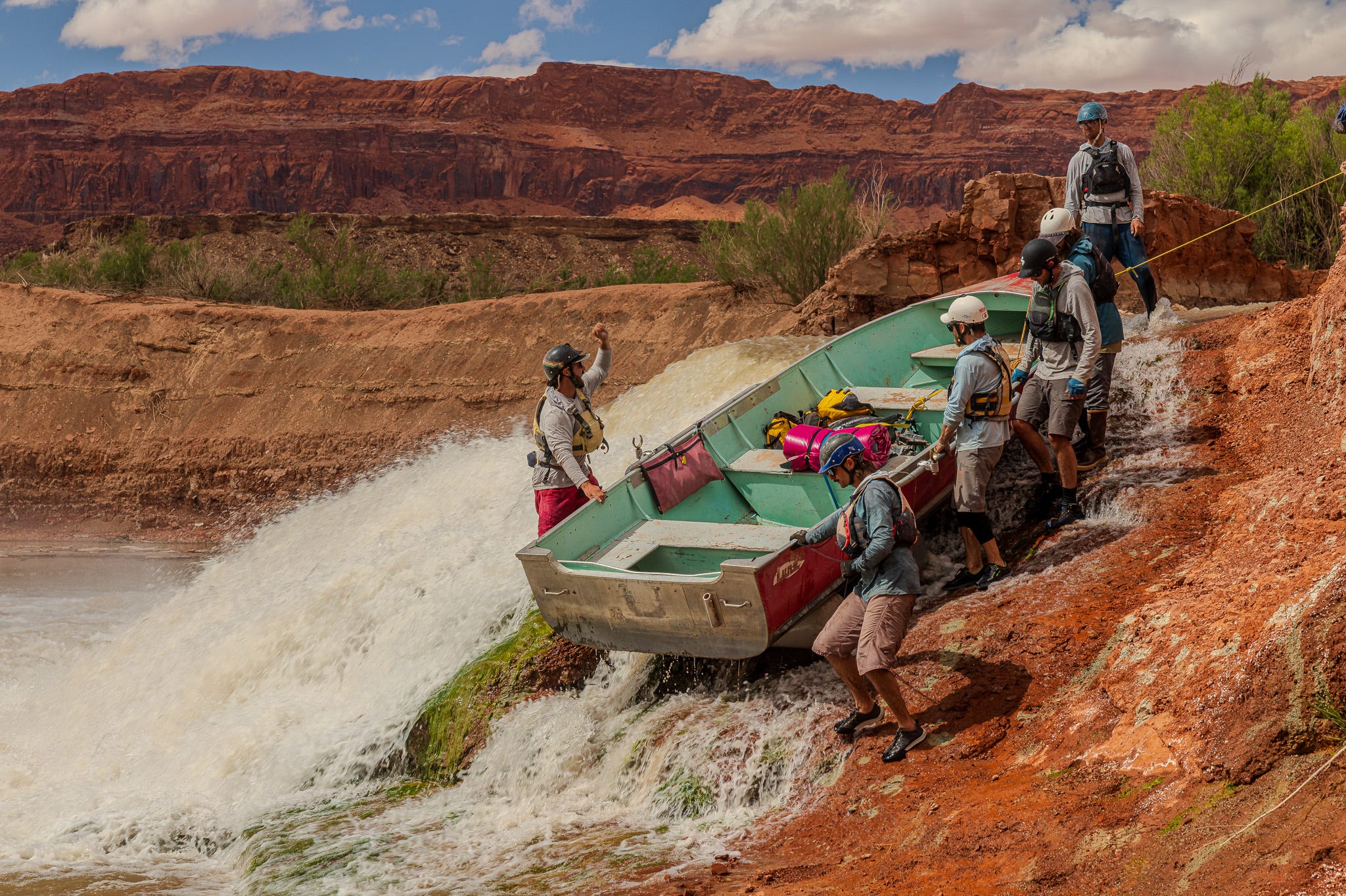
This past April, I stood on a sandbar in the lower San Juan River that did not exist when I was born. Neither did the rapid upstream of it, nor the one below. They are new features of an old river, carved over the past few years as Lake Powell retreated and the San Juan began digging out the sediment the reservoir had spent six decades swallowing. We had come to document the change, and the geology was spectacular, but what stayed with me afterward was the arithmetic. Every foot of canyon the river reclaims is a foot of reservoir that took years of snow to fill, and that may require snow we never see again to refill.
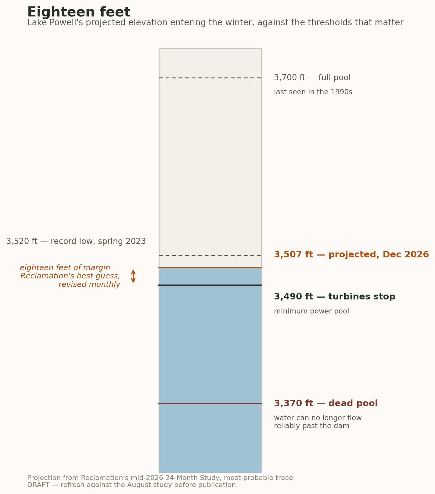
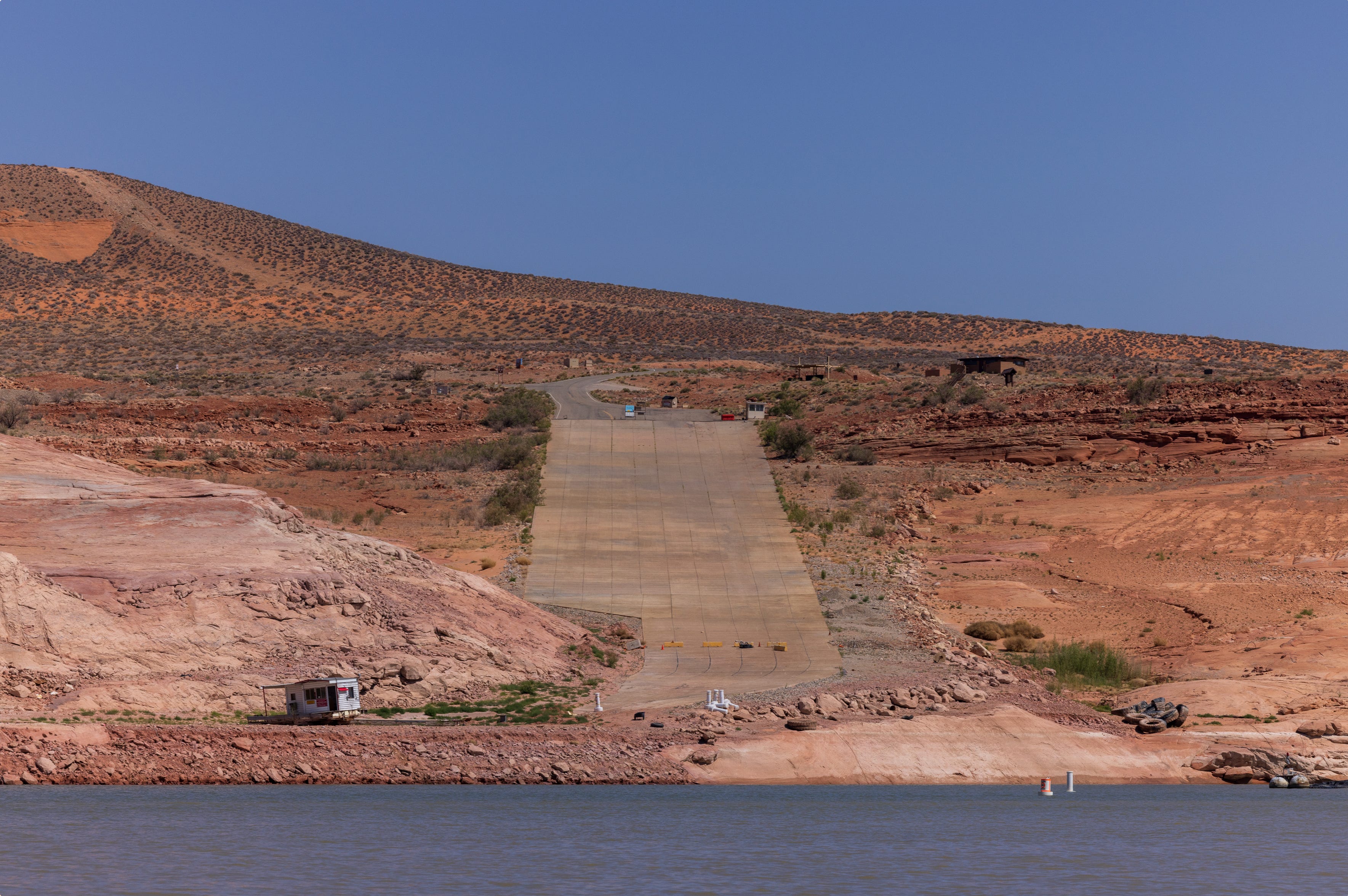
In its mid-July projections — a best guess, revised monthly, and lately the revisions have run downward — the Bureau of Reclamation expects Lake Powell to end the year near 3,507 feet above sea level, nearly two hundred feet below full. At 3,490 feet, Glen Canyon Dam can no longer generate electricity. Eighteen feet of projected margin, and even that is borrowed: Reclamation spent the summer releasing a million acre-feet of water from Flaming Gorge Reservoir, the Upper Basin’s savings account, to keep Powell from falling faster. An acre-foot is the volume that would flood a football field a foot deep — about 326,000 gallons, a year of water for two or three Southwestern households — which makes a million of them a year’s water for roughly two and a half million homes. That is the size of the loan. The runoff that reached the reservoir this year totaled 3.5 million acre-feet, thirty-six percent of average, among the worst years ever recorded on a river that has spent a quarter century breaking its own worst records.
Meanwhile, in the equatorial Pacific, sea-surface temperatures have been climbing since spring. In June, NOAA’s Climate Prediction Center issued an El Niño Advisory — the event is no longer forecast but observed — and gave it a ninety-seven percent chance of lasting through early spring, with real odds of reaching the intensity the press calls a super El Niño. The last three events of that class arrived in 1982, 1997, and 2015.
Over the coming months, everyone with a stake in the Colorado — water managers, tribal councils, governors, editorial boards, the forty million people who drink from the river without thinking about it — will read that forecast and form a picture of the winter ahead. I want to spend some time on why most of those pictures will be wrong, and not randomly wrong but wrong in predictable directions, because the errors have a psychology, and the psychology has victims.
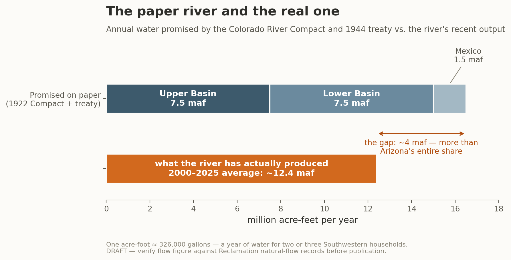
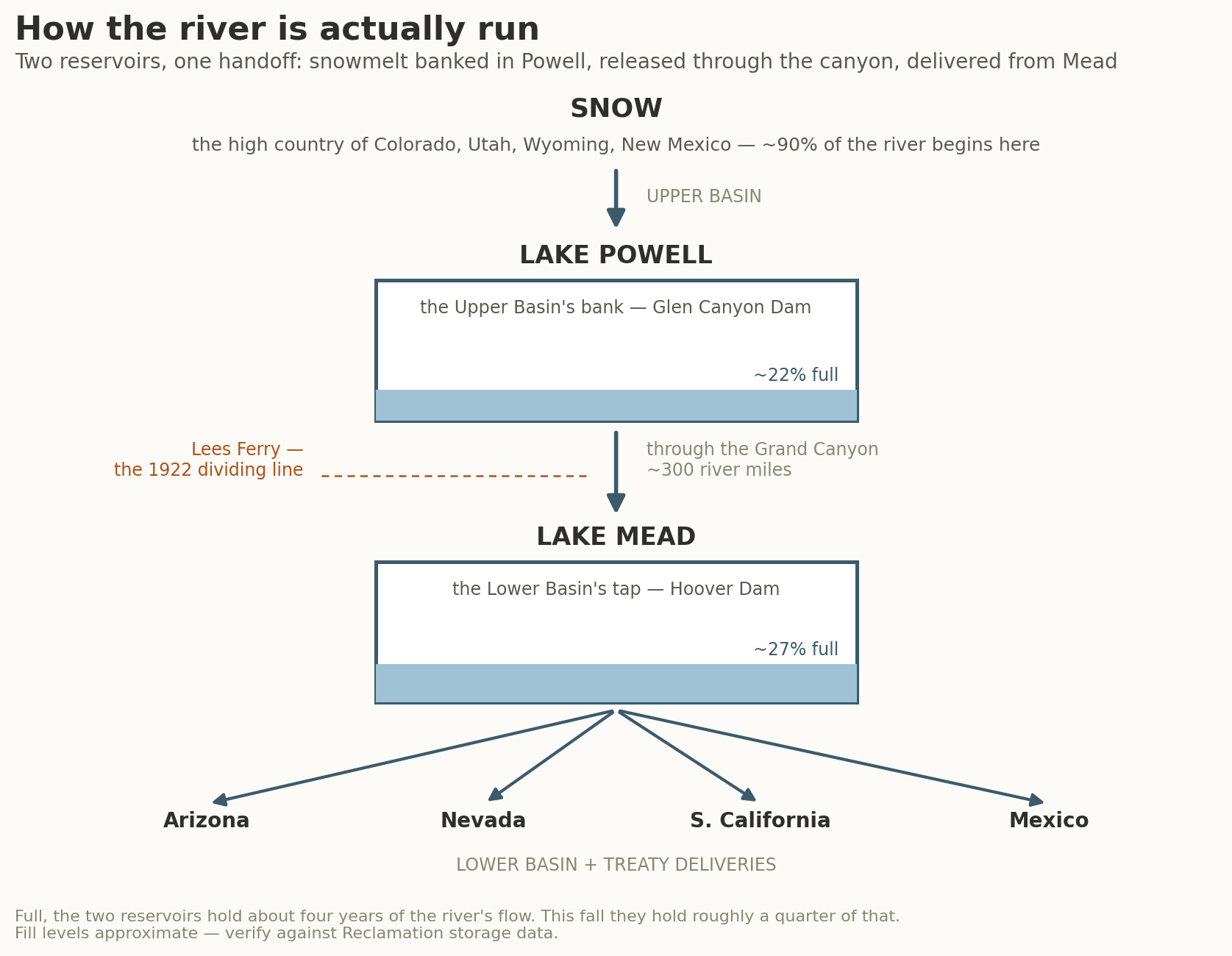
In 1922, the men who divided the Colorado among seven states worked from streamflow records gathered during one of the wettest periods the basin had seen in centuries. They split the river in two at Lees Ferry, a lonely gauging station in northern Arizona: everything upstream — Colorado, Utah, Wyoming, and New Mexico, where nearly all the snow falls — became the Upper Basin, and everything downstream — Arizona, California, and Nevada, where most of the people and farms are — the Lower Basin, each half promised the same generous share of the flow. A government hydrologist named Eugene Clyde La Rue spent years insisting the river could not supply what was being promised in its name; he was thanked for his diligence and ignored. The compact allocated roughly sixteen and a half million acre-feet of annual flow from a river that, over the past two decades, has produced closer to twelve and a half — a gap larger than Arizona’s entire annual share. Every fight on the Colorado since — every guideline, drought plan, and emergency accord — has been an argument over how to keep dividing a number that was never real.
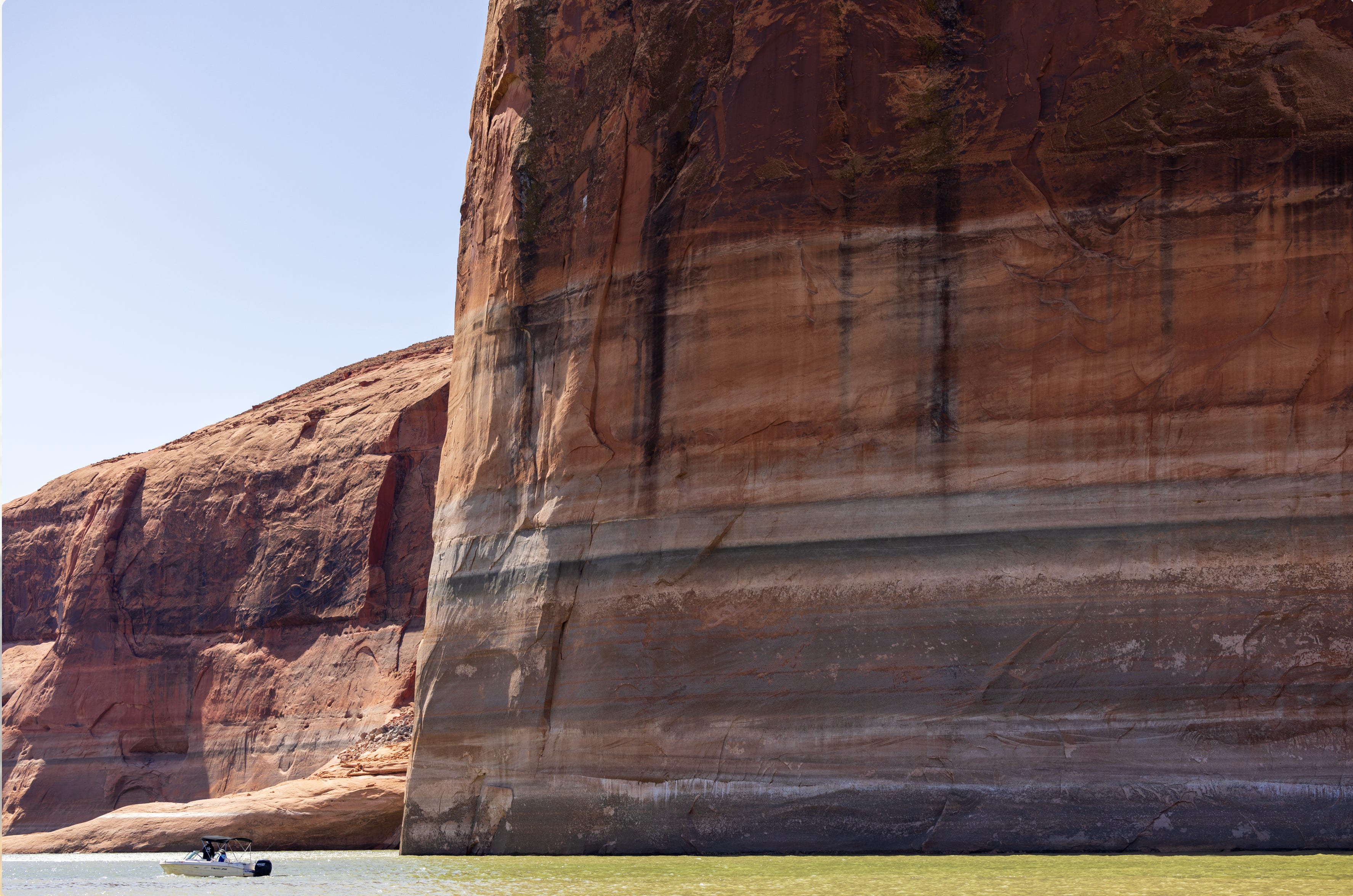
The dividing happens, in practice, through two enormous buckets. Lake Powell, behind Glen Canyon Dam at the head of the Grand Canyon, is where the Upper Basin banks its snowmelt. Three hundred river miles downstream, Lake Mead, behind Hoover Dam, is the Lower Basin’s tap: what Hoover releases becomes the supply for Arizona, Nevada, much of Southern California, and Mexico. Full, the two reservoirs together hold about four years of the river’s flow. This fall they hold roughly a quarter of that, and the white mineral ring on Mead’s canyon walls — the drought’s most photographed artifact — now stands taller than the Statue of Liberty. Each August, Reclamation studies the coming year and decides, according to rules keyed to the reservoirs’ elevations, how much water Powell will send down through the Grand Canyon to Mead, and how much Mead will release to the cities, farms, and country below.
The current generation of those rules expires on December 31, 2026. All of it at once: the 2007 shortage guidelines, the drought contingency plans layered on afterward, and Minute 323, the agreement that governs how the United States and Mexico share scarcity under their 1944 treaty. On July 31, the Bureau of Reclamation published the two-thousand-page environmental impact statement that lays out what would replace the domestic rules. It is not itself the decision — that comes with a Record of Decision the Interior Department has committed to signing by October 1, the deadline Secretary Doug Burgum set for the government after the states twice missed theirs. But the document names a preferred path, and the preferred path is not a set of rules at all. It is a framework: a process for writing rules in two-year installments through 2036, with a default that takes over whenever the seven states fail to agree. The default is the priority system, the nineteenth-century doctrine under which the oldest claims are paid in full before junior ones receive anything. Some claims on this river date to 1865.
The alternatives Reclamation analyzed were not conjured by the agency; they were brought to it. The states submitted proposals, and their arithmetic governs 2027 and 2028. A coalition of national environmental groups — Audubon, the Environmental Defense Fund, and others — submitted an alternative engineered to keep the reservoirs high. And a convening of basin tribes, working with Reclamation through 2024 and 2025, shaped an alternative built on proportional sharing: in shortage, everyone cuts together, regardless of the vintage of their paper. The agency modeled them all against twelve hundred possible futures, and by its own results the tribal alternative was the only one that reliably delivered water to every tribe in the basin. The preferred framework runs on the states’ math. The tribal alternative remains in the appendices, surveyed with great care and not taken.
Five tribes along the river’s main stem hold rights that predate the surrounding states; the model delivers them essentially full water in nearly every future. Thirteen others hold roughly 374,000 acre-feet — a year’s water for close to a million households — through Central Arizona Project settlements, water promised in exchange for surrendering larger claims, and under the default the model shows those deliveries collapsing during the very years the framework is meant to govern. The same arithmetic sorts the states: Arizona’s water is junior, so Arizona absorbs the deepest cuts; California’s is senior, which makes the default something close to its fallback position. And the Upper Basin’s standing grievance turns out, on inspection, to be a finding in the modeling appendices — its users fall short of their paper demand in every single year of the analysis, a quarter of it in a typical year, because their shortage is imposed not by rules but by creeks that fail to rise.
Mexico’s deliveries, the document insists, are not part of the federal action; they belong to the treaty, to be settled through the binational commission. Yet every alternative in the analysis models Mexico’s water reduced by a fixed 16.67 percent of any shortage — Mexico’s proportional share of the lower river — reaching forty percent of the treaty guarantee at the framework’s maximum. The cuts are computed to the acre-foot and disclaimed in a footnote on the same page, while the binding version is negotiated out of public view, due before New Year’s Eve.
Dead pool — the elevation at which Lake Mead can no longer reliably release water downstream — occurs in roughly one of every five modeled futures under the chosen framework, and the rules for allocating water in that world do not exist. Reclamation deems them too speculative to draft. Federal environmental documents traditionally include sheets stamped “This page intentionally left blank,” and this one is no exception; it is just that here, one of the blank pages is the plan for the worst case.
If signed as proposed, the framework takes effect January 1. How it behaves over the next decade depends almost entirely on whether the states strike a deal, and whether the states strike a deal depends, more than anyone in a suit will say aloud, on what falls out of the sky between November and April.
Centuries ago, fishermen off the coast of Peru noticed a warm current that arrived each year around Christmas and named it El Niño de Navidad, for the child whose birthday it kept. What they were seeing, science later established, was the edge of the largest recurring disturbance in the planet’s climate. In most years, the trade winds blow steadily westward across the tropical Pacific, piling the ocean’s warmest water up against Asia. Every few years the winds slacken, and the warm water — a pool the size of a continent, several degrees hotter than the sea around it — sloshes back east toward the Americas. The migration matters far beyond the tropics, because the ocean’s hottest water anchors the planet’s biggest thunderstorms, and those thunderstorms anchor the jet stream, the high-altitude river of wind that steers winter storms across North America. Move the warm pool and you move the steering current. In the West, the move usually opens the storm door across the southern tier — more Pacific storms swinging into California, Arizona, New Mexico — while the Northwest and the northern Rockies tend to dry out. The cool-water opposite phase, La Niña, tips the seesaw the other way, and has spent much of the past decade doing exactly that, at the Southwest’s expense. Forecasters watch the cycle as closely as they do because it is one of the few features of a coming winter that can be seen months in advance. It is also the oldest named climate signal we have.
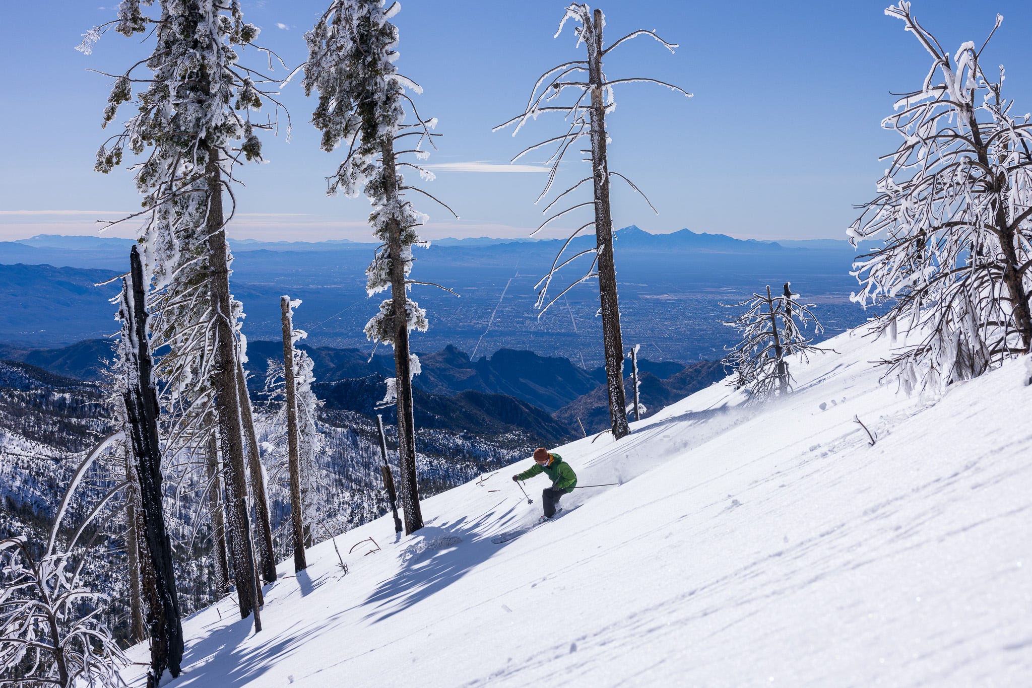
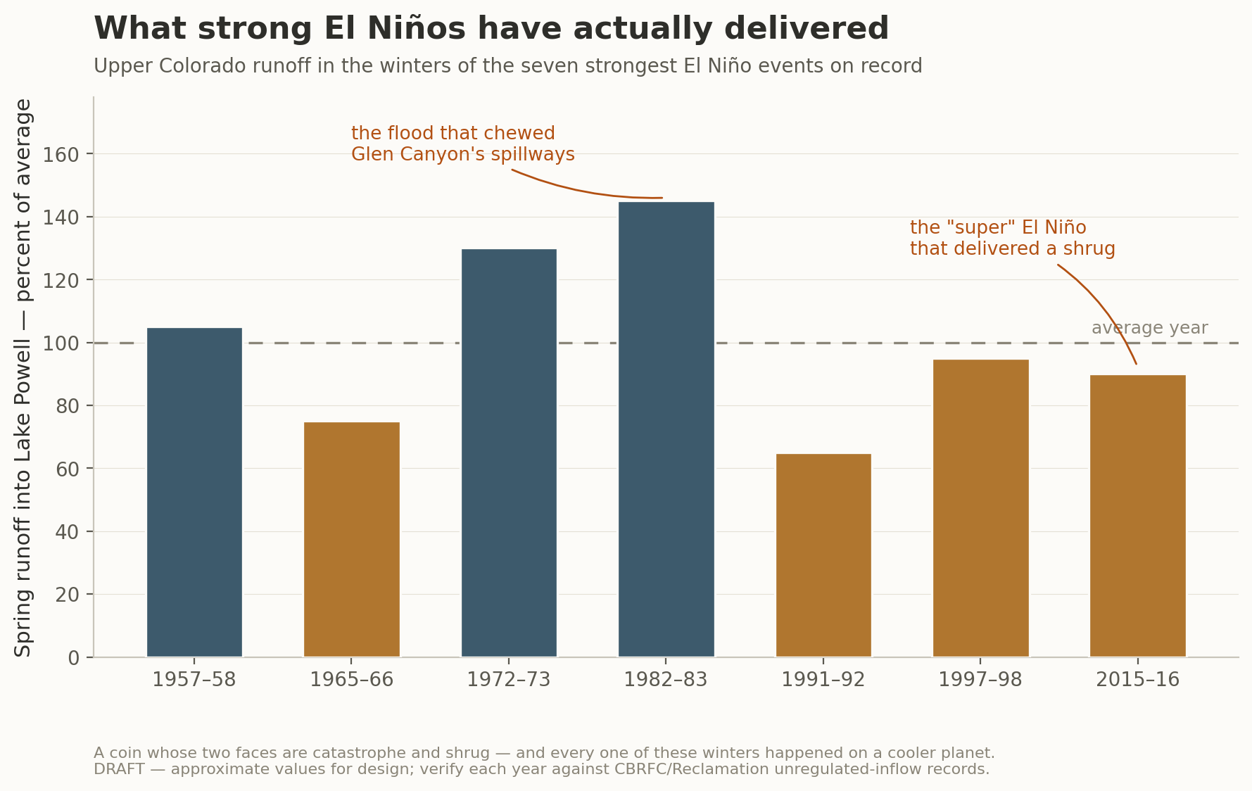
In the American West, then, El Niño carries a folk meaning — wet winter — and for the deserts where I live, the folk meaning mostly holds. The catch is that the Colorado River is not made in the deserts. Roughly ninety percent of its flow begins as snow in the high country of Colorado, Utah, and Wyoming, and that country sits in what climatologists call the ENSO transition zone: the seam between the wet signal to the south and the dry signal to the north, a term of art meaning the signal cannot be trusted. The record of strong El Niños in the headwaters reads less like a pattern than a dare.
Recent research has begun to explain how the dare is constructed. El Niño turns out to come in flavors — events centered in the eastern Pacific behave differently from those centered farther west, near the dateline, and they steer moisture toward different parts of the continent once it arrives. The mountains then complicate whatever the ocean sends: a 2023 study in Nature Water, built on gauge records reaching back to 1871, found that the Intermountain West’s topography amplifies the underlying ENSO precipitation signal severalfold — the ranges wring out whatever the pattern delivers, in whichever direction it happens to err. And the pattern itself is not standing still. Modeling work led by Wenju Cai and colleagues projects that extreme El Niño events grow substantially more frequent as the planet warms, even as the atmospheric pathways that carry their influence shift. The signal we are trying to read is changing while we read it.
In 1983, the snow came late, enormous, and then melted all at once under a warm June, and the runoff arrived at Glen Canyon Dam faster than anyone had planned for. The spillways — tunnels bored through the sandstone on either side of the dam — began to cavitate: vapor bubbles collapsing against the tunnel linings with enough violence to strip the concrete, then the steel reinforcement, then the rock itself. Engineers standing on the dam could feel the rumble of debris the size of cars moving through the tunnels below their feet. The reservoir kept rising. In the end, the operators of one of the largest pieces of infrastructure in North America held back the Colorado River with sheets of plywood bolted to the tops of the spillway gates. It worked, which is either a tribute to American engineering or the punch line to a joke about it, depending on the day you ask me.
Thirty-two years later, the 2015–16 event arrived with comparable strength and a global chorus of anticipation, and delivered to the Upper Basin a winter of almost aggressive ordinariness. No flood, no rescue, no story. The honest translation of “super El Niño” for this river, even before the climate changed, was a wetter Phoenix, probably; a wetter Los Angeles, probably; and for the mountains that fill the reservoirs, a coin whose two faces are catastrophe and shrug. That coin was minted in the old climate. We are not in the old climate.
When a forecast like this one arrives, every mind that receives it reaches for precedent. Psychologists call it anchoring — the tendency to seize an initial reference point and adjust insufficiently away from it — and it is among the most thoroughly replicated findings in the study of human decision-making, one of the few that sailed through the field’s replication crisis intact. The anchors available for this winter are 1983, 1998, and 2016. The trouble is that all three were set in a world that no longer exists. The 1983 flood occurred on a planet more than a degree cooler than the one this El Niño is forming in, and the machinery that once converted Pacific warmth into Rocky Mountain streamflow has been rebuilt in the interim, link by link.
Each degree of warming lifts the boundary between rain and snow a few hundred feet up the mountainside, and strong El Niño winters run warm even before you add the hottest global baseline ever measured. Storms that blanketed mid-elevation terrain in 1983 will, in 2027, rain on it. Hydrologists have a name for the result: snow drought, which comes in two kinds — the dry kind, when little falls at all, and the warm kind, when plenty falls but too much of it as rain. Utah’s Wasatch produced a textbook warm one just last winter: precipitation landed near its usual marks while the snowpack ran far below them, the difference having come down as rain on ranges the whole water system assumes will bank it as snow.
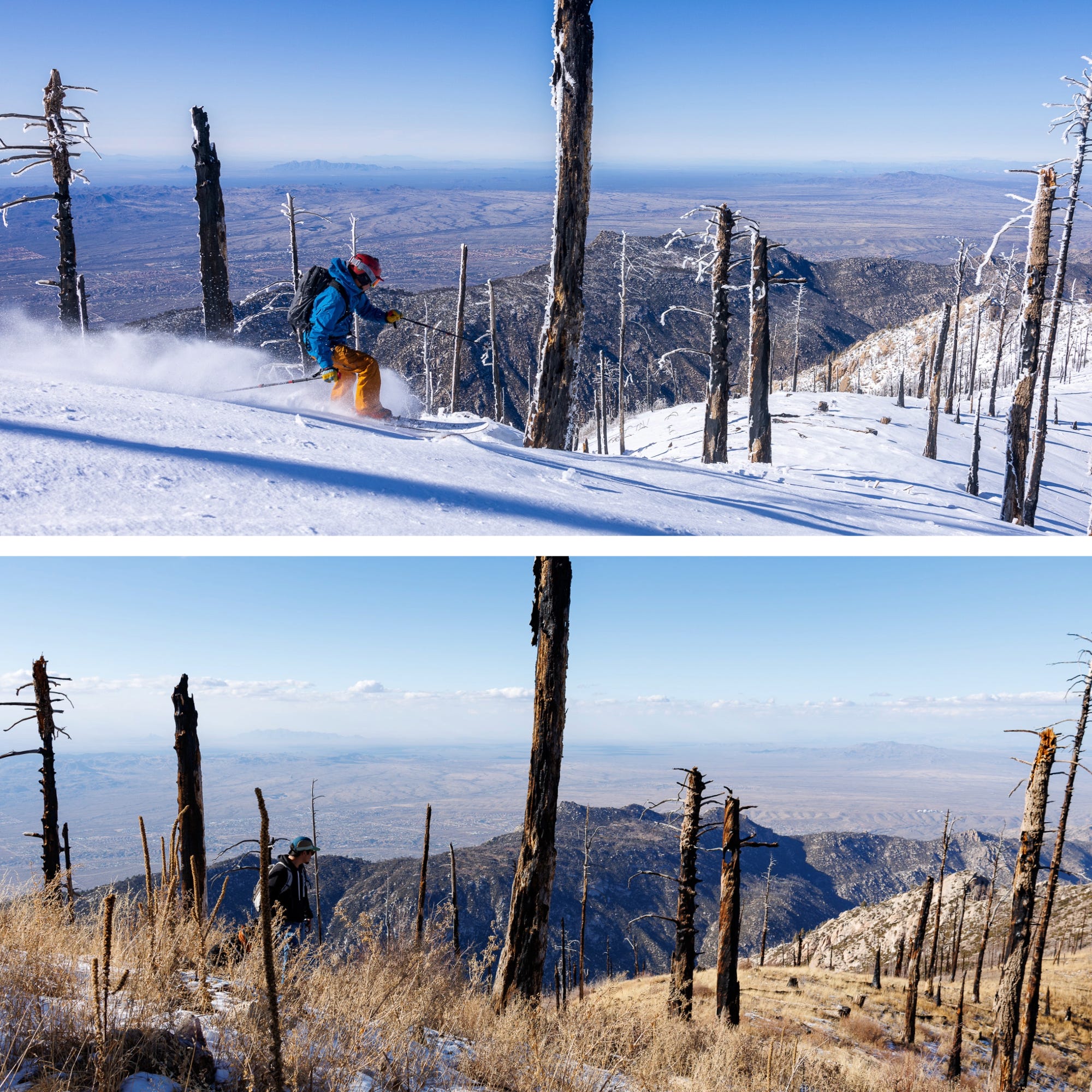
Snowpack is more than water; it is a schedule. The pack holds winter’s precipitation at altitude and meters it into the river across April, May, and June — the timetable the entire system is built around. Managers set the year’s releases from the spring runoff forecast, so water that arrives in January arrives before anyone has decided what to do with it. Reservoirs downstream keep space empty through winter in case of floods, so a midwinter surge often has to be passed along rather than saved. And water that comes down months early spends those months in the open — soaking into dry ground, evaporating off warm surfaces — instead of waiting as ice at ten thousand feet. A warm wet winter and a cold wet winter can deliver the same precipitation and profoundly different rivers.
In 2021, the Upper Basin caught eighty-nine percent of its median snowpack — a winter any skier would call fine — and the river received thirty-two percent of its average runoff. The difference was consumed by soils so desiccated from years of drought, and a spring so hot, that the watershed drank the melt before the streams could carry it. One year, and it should have permanently severed the assumption that what falls is what flows. Heading into this winter, after the worst inflow year on record, the basin’s soils are again profoundly depleted. The first installments of any melt are already spoken for.
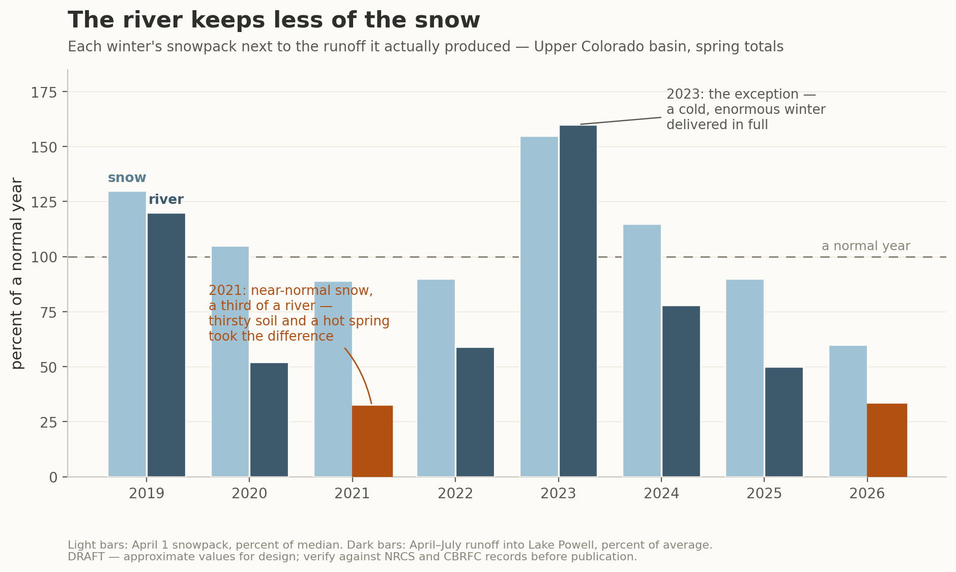
Dust is one factor that complicates this picture further. The Colorado’s snow falls downwind of drylands that a century of grazing, drilling, and drought has stripped of their protective crusts, and what the wind lofts off them settles on the snowpack and darkens it. Darkened snow absorbs sunlight; the snow scientist Thomas Painter and his colleagues have estimated that dust-driven early melt pulls the river’s peak runoff weeks forward and costs it on the order of five percent of its annual flow. The atmosphere claims another share outright: sublimation, in which wind and dry air turn snow directly from ice to vapor, and evaporation off the pack’s warming surface together remove a slice of the snowpack that grows as the air runs hotter, drier, and windier — in bad years across the Rockies, a tenth or more of what fell, gone without ever becoming a stream. The accumulated toll is no longer subtle in the observations: spring snowpack across the western United States has declined since the mid-twentieth century by a volume researchers have compared to Lake Mead itself, and the field’s standing synthesis — a 2021 review titled, without much euphemism, toward a “low-to-no-snow future” — projects that under continued emissions, the episodic snow droughts of recent decades become persistent ones in the second half of this century. The natural reservoir is being decommissioned ahead of the concrete ones.
The mechanisms sum to numbers, and the numbers have been converging from independent directions for a decade. When Brad Udall and Jonathan Overpeck examined the river’s twenty-first-century decline, roughly a third of it turned out to be the work of temperature alone — precipitation had wobbled, but heat had taxed every drop that fell — and the name they gave the phenomenon stuck: hot drought. Tree rings tell the longer version: the years since 2000 are the driest twenty-two-year stretch this region has seen since the 800s, and about two-fifths of that severity, by Park Williams’s accounting, belongs to human-caused warming. The hydrologist Chris Milly, with Krista Dunne, put a rate on it in Science — the Colorado loses roughly nine percent of its flow for each degree Celsius of warming, much of it to lost snow reflectivity and a thirstier atmosphere. Milly is also the scientist who, in 2008, co-wrote the paper whose title became the epitaph of twentieth-century water planning: “Stationarity Is Dead.” The past, it argued, no longer generates reliable statistics about the future.
The federal government, to its credit, half agrees. The entire environmental impact statement rests on a method called Decision Making under Deep Uncertainty, which abandons prediction altogether and instead stress-tests each alternative against that battery of futures, wet and dry and strange. It is, on its face, a serious attempt to take the death of stationarity seriously.
The statistician George Box gave applied science its most durable warning: all models are wrong, but some are useful. Whether a model is useful depends on whether the people relying on it understand where it errs — and whether anyone tells them. There is a whole discipline devoted to that telling; I trained in it, in the risk-analysis program Granger Morgan built at Carnegie Mellon, and its working rule fits in a sentence: never hand a decision-maker a single number without its range, because the range is where the decision actually lives. A number that shows up without its range is selling something. Morgan spent his career pushing federal agencies to show theirs — to say plainly what is measured, what is estimated, and what is simply not known — and his colleague Baruch Fischhoff added the finding that matters most for this winter: ordinary people handle honestly communicated uncertainty far better than officials fear, and handle discovered overconfidence far worse. Every forecast you will hear between now and April is a model output wearing more or less of its uncertainty in public, and the most useful habit a reader can bring to the season is asking where the range went.
Held to that standard, the new river document is both admirable and evasive. Admirable because twelve hundred futures, robustness tables, and vulnerability analysis are what honest uncertainty looks like when an agency actually attempts it. Evasive in ways the public record has already documented. The technical comments filed by the environmental coalition warned that the analysis risks treating all of its futures as equally plausible — a democracy of scenarios in which hydrologies borrowed from the wetter twentieth century get the same vote as the river we have actually watched for twenty-five years — when the observed trend argues for weighting the dry tail. The Sierra Club pressed a blunter absence: the document contains no operational protocols for running Glen Canyon Dam below 3,500 feet, the territory one bad winter away. One more evasion turns up only if you go looking for a phrase. The current administration has made plain that it will not speak of climate change, and across the hundreds of pages of this document I have read closely, it scarcely does. Two thousand pages modeling a drying river, and the drying arrives on the page as weather without an author — a fate, not a mechanism. Read this way, the uncertainty method is not only good science; it is a diplomatic instrument, a mathematics that lets the agency obey the physics without disobeying the politics. You can forbid a word. The reservoirs have not been informed.
So the document’s mathematics concede that the analog years are broken, even as its vocabulary declines to say why, and the politics stacked on top of it — wait for a states’ deal, let the default run, leave the worst case blank, see how the winter develops — assume the opposite of what the mathematics concede: that hydrology will behave familiarly enough to leave time for negotiation. The math and the politics are wagering against each other. This coming winter is the settlement date.
Knowing that the anchors for snowfall and precipitation are broken does not free anyone from them — I study these patterns and still catch myself reaching for 1983. From the inside, the errors do not feel like errors. They feel like reasonableness. So rather than a catalogue of biases, here are four questions, each grounded in findings sturdy enough to build on, that anyone can carry through the forecast season — field equipment for reading the winter.
The first: what is the denominator? Every snowpack report you encounter this winter will arrive as a percentage — “112 percent of normal” — and the word doing the quiet work is “normal.” It refers to the 1991–2020 median, a baseline that contains the megadrought within it. The measuring stick has shrunk along with the thing it measures, not through deception but through routine statistical maintenance; the reference period rolls forward a decade at a time, and each roll forgets a little more of the river that the reservoirs were built for. A winter can hit its number and still shortchange the system. This is also how 2023, celebrated across the basin as a generational rescue, purchased roughly eighteen months of reservoir recovery against a twenty-year structural deficit and entered memory as salvation anyway. Ecologists call the phenomenon shifting baselines. On the Colorado, it might better be called amnesia with a spreadsheet.
The second: compared to what? This is the framing question, and it explains more of the basin’s politics than any map. The same acre-foot of reduction is a catastrophe when measured against a state’s compact entitlement, an inconvenience when measured against its actual recent use, and an inevitability when measured against the river that exists. None of the parties are lying; they are anchored to different reference points, and decades of research on framing show that the reference point, not the quantity, determines whether a change is experienced as a loss. Even the vocabulary participates. A “shortage,” the system’s official term, implies a temporary deviation from a rightful normal — a word that presumes the paper river is the real one and the actual river is the aberration. When you hear a number this winter, from any party, ask what it is being measured against. The answer is usually the argument.
The third: where are the cameras? Public attention to risk tracks vividness — what the literature calls availability — and a super El Niño is, above all else, a machine for generating vivid weather where people live. Atmospheric rivers striking the California coast. Flooded intersections in Scottsdale. Powder reports from the resorts. All of it real, none of it the river. The Colorado’s supply is manufactured in high, unphotographed country whose response to this pattern is anyone’s guess, and the winter now taking shape is capable of producing a maximally vivid public impression of abundance that the river itself never receives. The images will say the drought is over. The gauges will say what they say. Watch the gauges.
The fourth, and the one I trust most: what certain loss is the speaker avoiding? Every party in this negotiation faces only losses; there is no deal on the Colorado that gives anyone more water. And the most durable finding in the study of choice — the one that earned Kahneman his Nobel — is that people confronting a certain loss will prefer a gamble that might avoid it, even a poor gamble, to the signature that makes the loss real. The states have missed two federal deadlines. Colorado’s attorney general has announced the state is prepared to litigate. Arizona says its compromises keep dying in committee. Into this room now walks a strengthening super El Niño: the most respectable gamble ever handed to a negotiator who does not want to sign. “Let’s see how the winter develops” will be said in every accent the basin possesses, and it will sound, in every one of them, like prudence. It is a wager, placed at odds the climate stopped honoring years ago. There is a related finding worth one more sentence: people systematically underweight risks they have read about but never lived — and no one alive has seen Lake Mead at dead pool, so the mind, encountering an eighteen percent probability of the unlived, rounds it toward zero.
Granger Morgan, my former department head of my graduate program, discipline me to label the forecast that follows: these are structured judgments, not derivations — my best current reading of an ambiguous signal, stated with the ranges left visible, and revisable the moment the mountains start reporting. Three winters are possible, and their shapes matter more than their rankings.
The likeliest, given the geography of the pattern, is a split basin: the El Niño delivers to the southern tier — genuinely good news for Phoenix’s in-state reservoirs and for Southern California’s demands on the river — while the Upper Basin’s snow arrives ordinary and its runoff, filtered through dust on snow events and thirsty soils, arrives worse. This is also the hardest winter to interpret, because it will look wet on television while Powell continues to fall, and every mental model above will be earning its keep at once.
The second is the true bailout is possible. A super El Niño represents a staggering quantity of moisture, and if the storm track sets up a few hundred miles north of its climatology, the high country gets buried, Powell rises forty feet, and the basin exhales. But warming has repriced even rescue. The storms of 1983, replayed today, would deliver perhaps a fifth less river — higher snowlines, hungrier ground, a hotter spring; a judgment assembled from the flow studies, not a measurement, and I would defend the direction more firmly than the digit. More of what arrived, moreover, would come as midwinter flow, which is a scheduling problem, rather than as snowpack, which is a bank. A bailout also carries a cost that no one prices: 2023 demonstrated that a single good year supplies exactly enough relief to suspend the negotiating without shrinking the deficit. A great winter would be an unambiguous mercy for everyone facing cuts in 2027, the junior tribes above all, and a quiet setback for ever repairing the arithmetic underneath them. The river can still get lucky. It cannot get lucky often enough for luck to be a plan.
The third winter is the one 2021 taught: precipitation that disappoints outright, or lands respectably and converts badly. Given where the system is projected to start — Powell perhaps eighteen feet above its turbines, the Flaming Gorge reserve already partly spent — this scenario requires no exceptional failure. It requires a repetition of the year we just had. And it would deliver the blank page, the dead-pool question with no written answer, into the first year of a ten-year plan.
The season can be followed in real time, and the calendar is worth keeping. Reclamation’s next 24-Month Study, due in mid-August, re-draws the elevation projections as the hydrology reports in and sets the official operating conditions for 2027. The Record of Decision, the signature that turns the preferred framework into law, can come no sooner than thirty days after the Final EIS and is due by October 1 — the deadline Interior set for itself after the states missed theirs, and the start of the new water year. Any resumption of seven-state talks matters as much as any storm, because the framework is designed to absorb a consensus deal whenever one materializes. The Mexico agreement is due by December 31, and will arrive from a closed room. From January onward, the snow-telemetry numbers begin — remember the denominator — and the April-through-July runoff forecast follows. Above all of it sits the one figure that cannot be spun: runoff efficiency, the ratio between what falls in the mountains and what arrives in the river. That gap is where the new climate lives, and it is the number I will be watching from Tucson while the television tells me it is raining.
The West built a legal civilization on the premise that a river is a fixed quantity divisible by lawyers, spent two decades papering over the discovery that it is not, and now enters the first winter of a ten-year framework holding a forecast it can no longer read by the old lights. The signal still arrives on schedule — the South Pacific has kept its half of the fishermen’s bargain — but the country it must cross to become a snowbank in Colorado has been rebuilt underneath it. The government’s own mathematics have already made their peace with this; twelve hundred futures is what institutional humility looks like when it must be expressed in a spreadsheet. The remaining work belongs to the rest of us — tribal water offices, city utilities, negotiators, readers — and it consists of catching our habits of mind up to the document’s math before the weather grades the exam.
The cost of failing will not be spread evenly. It never is on this river. It settles farthest from the cameras: on settlement water filed deepest in the appendices, on a treaty being rewritten behind a closed door, on a delta where the Cocopah are watering four hundred acres of young willows from wells, beside a channel that has been dry so long the maps have started to hedge. The question this winter asks is not whether it will be wet. It is whether we still know what wet means — and whether we can keep asking honestly once the rain starts falling on Phoenix and everyone, understandably, wants to stop.
Sources, data, and further reading
The federal record. The Post-2026 Colorado River Reservoir Operations Final EIS (Bureau of Reclamation, July 31, 2026) is available in full at usbr.gov, and the claims in this essay draw principally on: Technical Appendix 18 (Indian Trust Assets), the source for the tribal priority-group modeling, the fallowing estimates, and the dead-pool language; Appendix K (Mexico Shortage Sensitivity Analysis), the source for the 16.67 percent proportionality formula and the Upper Basin’s modeled every-year shortfalls; the International Border Region appendix, for the delta, the Limitrophe, and the Cocopah restoration site; and Chapter 4 (Consultation and Coordination), for the authorship of the alternatives, including the tribal convenings that shaped the Enhanced Coordination Alternative. Reservoir elevations and inflow figures come from Reclamation’s 24-Month Studies, which are revised monthly — the numbers in this essay reflect the mid-2026 study and will have shifted by the time you read this. The Record of Decision timeline reflects Interior’s public commitment to finalize by October 1, 2026.
The forecast. El Niño status and probabilities come from NOAA Climate Prediction Center’s monthly ENSO Diagnostic Discussion (cpc.ncep.noaa.gov), which is the document to watch, monthly, all winter.
The climate science. Milly & Dunne, “Colorado River flow dwindles as warming-driven loss of reflective snow energizes evaporation,” Science (2020) — the ~9 percent per degree figure. Milly et al., “Stationarity Is Dead: Whither Water Management?,” Science (2008). Udall & Overpeck, “The twenty-first century Colorado River hot drought and implications for the future,” Water Resources Research (2017). Williams et al. on the megadrought’s severity and human attribution, Science (2020), updated in Nature Climate Change (2022). Mote et al. on declining western snowpack, npj Climate and Atmospheric Science (2018) — the Lake Mead volume comparison. Siirila-Woodburn et al., “A low-to-no-snow future and its impacts on water resources in the western United States,” Nature Reviews Earth & Environment(2021). Painter et al. on dust-driven early melt and flow loss, PNAS (2010). Stagge et al. on orographic amplification of ENSO signals in the Intermountain West, Nature Water (2023). On extreme El Niño frequency under warming, the line of work led by Wenju Cai beginning in Nature Climate Change (2014).
The decision science. Morgan & Henrion, Uncertainty: A Guide to Dealing with Uncertainty in Quantitative Risk and Policy Analysis (Cambridge, 1990). Kahneman & Tversky, “Prospect Theory,” Econometrica (1979). Tversky & Kahneman on availability and anchoring, Science (1974). Soga & Gaston on shifting baseline syndrome, Frontiers in Ecology and the Environment (2018). Hertwig & Erev on the description–experience gap, Trends in Cognitive Sciences(2009). George Box’s aphorism appears in various forms from 1976 onward; the sentiment survives every citation format.
The history. Kuhn & Fleck, Science Be Dammed: How Ignoring Inconvenient Science Drained the Colorado River(University of Arizona Press, 2019) — the definitive account of E.C. La Rue and the compact-era hydrology. The 1983 spillway crisis is documented in Reclamation’s own engineering literature and retold in that book.
The public record on the EIS’s gaps. The equal-plausibility critique appears in the joint technical comments filed by the environmental coalition during the draft comment period; the below-3,500-feet critique in the Sierra Club’s comment letter. Both are in Reclamation’s public comment docket. The observation about climate language is my own, from searching the document — I encourage readers to replicate it.
The charts. Snowpack figures are NRCS SNOTEL April 1 snow-water equivalent for the Upper Colorado basin, percent of the 1991–2020 median — note that caveat; it is the essay’s second question. Runoff figures are April–July unregulated inflow to Lake Powell, percent of average, from Reclamation and the Colorado Basin River Forecast Center. Allocation and flow figures in the compact chart are from Reclamation’s natural flow records.
A note on uncertainty, kept. The scenario judgments in this essay are mine, stated with the confidence they deserve, which is moderate. The elevation projections are Reclamation’s and change monthly. The winter will do what it does. If the numbers move, I will say so — that is what the subscription is for.
Wow, what a long and interesting read (something I rarely say anymore).
The casino always wins. We keep betting against it and like a gambler a single win only encourages us.